We provide cutting-edge robotic platforms, autonomous navigation systems, and connectivity solutions that enable you to build sophisticated autonomous systems with European precision and reliability.
The World's First POE LiDAR-Based IP Camera
Revolutionary 3D perception technology combining industrial-grade LiDAR with intelligent surveillance for next-generation security and monitoring applications. Powered by Hesai's FTX solid-state LiDAR.
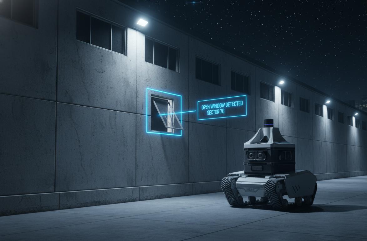
Unlike traditional cameras, LiCAM is fully GDPR-compliant by design—it perceives shapes, distances, and movement, but never identities. No faces, no personal features, no recognition. Perfect for real-time crowd monitoring at large events, public spaces, and smart city applications where privacy and transparent data matter.
Seamless Integration for Hesai FTX Solid State LiDAR
Simplify your LiDAR deployment with our compact adapter that converts Automotive Ethernet T1 to standard RJ45 while delivering POE+ power—one cable for power and data. Also functions as a general-purpose Gigabit POE to T1 converter with 30W output for robotics and industrial applications.
Experience the full range of Hesai LiDAR sensors in action at our European showroom. Meet our technical experts, test different models, and discover which solution best fits your application. Schedule a personalized demonstration at our European facility.
Design your ideal robotic payload with our comprehensive sensor solutions. Choose from a wide range of vision, range sensing, navigation, computing, and environmental sensing technologies to create a payload perfectly tailored to your application needs.
Our navigation layer now supports the Hesai FTX solid-state LiDAR for enhanced detection of small obstacles—including rail track debris, low-profile hazards, and ground-level obstructions. Ideal for railway inspection, industrial patrol, and autonomous navigation in challenging environments.
Learn more about FTXOur payloads are compatible with multiple robotic platforms:
Click a button above to load a 3D model
Or use "Browse Model File" to select any OBJ, GLB, or GLTF fileThis configuration consists of 3 fully sealed IP56 configurable layers. Layers are stackable and modular.
Configurable compute with indoor/outdoor navigation. Now with Hesai FTX LiDAR for small obstacle detection.
Up to 12 camera feeds between Thermal and optical (plus night vision) cameras
Optional outdoor GNSS antennas, optional warning light, optional 3D LiDAR. LEDs on the side act as status indicators
Robust, autonomous robotic platforms designed for demanding outdoor environments. Built with European precision and reliability.
Rendered
Tracked Platform
Available Q3 2026
High-performance tracked platform designed for challenging terrain and harsh outdoor conditions. Ideal for applications requiring superior traction and stability.
660 x 584 x 340 mm
55 kg
70 kg
1.5 m/s
30° (~58 %)
Zero turn radius
120 mm
-40°C to +80°C
48V Li-ion battery
3-4 hours
Inductive charging (up to 1KW)
250W x 2 (DC brushed), 15 Nm rated torque
IP66
CAN
Rendered
Wheeled Platform
Available Q3 2026
Agile wheeled platform optimized for speed and efficiency on flat and moderate terrain. Perfect for applications requiring rapid deployment and high mobility.
990 x 670 x 390 mm
50 kg
100 kg
~2.0 m/s
~30° grade (≈58 % slope)
Zero turn radius
150 mm
-40°C to +80°C
48V Li-ion battery
3-4 hours
Inductive charging (up to 1KW)
4x 200W brushless DC motors
IP66
CAN
Professional-grade navigation software packages designed for indoor and outdoor autonomous operations. Built on proven ROS 2 architecture with advanced SLAM, path planning, and sensor fusion capabilities.
All Ursa Robots will be powered by UrsaNAV. The software can also be integrated into OEM platforms.
UrsaNAV offers two specialized software packages, each optimized for different operational environments. Whether you need precise indoor navigation for warehouses and factories, or robust outdoor navigation for industrial sites and challenging terrain, we have the solution tailored to your specific application needs.
Advanced indoor autonomous navigation for warehouses, factories, and indoor facilities
Accurate self-localization using LiDAR-based SLAM, enabling operation in GPS-denied or dynamic environments.
Creation and continuous updating of high-resolution 2D occupancy grids and 3D point-cloud maps of the environment.
Reliable detection of static and dynamic obstacles with real-time avoidance and safety margins.
Efficient global and local path planning with smooth trajectories, waypoint navigation, and replanning around obstacles.
Robust performance in changing environments, filtering out moving objects and adapting maps and plans in real time.
Seamless fusion with IMU, wheel odometry, GNSS, and cameras, built on ROS 2 for compatibility with standard navigation stacks and custom nodes.
Robust outdoor autonomous navigation for industrial sites, campuses, and challenging terrain
Precise outdoor positioning using GNSS (RTK-ready), with support for large-scale environments and geo-referenced maps.
Real-time detection and avoidance of static and dynamic obstacles using LiDAR, ensuring safe navigation in unstructured terrain.
Fusion of GNSS, IMU, wheel odometry, and LiDAR to maintain robust localization during GNSS dropouts or degraded conditions.
Long-range route planning using GPS waypoints, geo-fences, and mission-based navigation with continuous replanning.
Adaptation to outdoor terrain features such as slopes, uneven ground, and vegetation, with configurable safety thresholds.
Built on ROS 2 with support for Nav2, custom actions, and reliable operation on Linux-based embedded systems.
We develop comprehensive software and hardware solutions for autonomous navigation robotic systems. Our end-to-end development services cover every aspect of your robotic platform.
From concept to production, we design and build custom robot chassis tailored to your specific application requirements. Our expertise spans mechanical design, sensor payload development, and seamless multi-sensor integration.
Our custom robot platforms are deployed in demanding applications requiring autonomous navigation and intelligent perception
Autonomous mobile robots equipped with advanced sensors for 24/7 security monitoring, threat detection, and perimeter surveillance in industrial facilities, warehouses, and critical infrastructure.
Automated inspection robots for infrastructure, industrial plants, and confined spaces. Equipped with high-resolution cameras, thermal imaging, and LiDAR for comprehensive asset monitoring and defect detection.
Intelligent perimeter security robots with AI-powered detection of open windows, doors, gates, and fence breaches. Continuous monitoring of access points and immediate alert generation for security teams.
Our complete navigation software stack enables precise autonomous operation in both indoor and outdoor environments. Built on industry-standard frameworks with custom algorithms optimized for real-world performance.
Indoor & outdoor navigation using LiDAR and GNSS
Simultaneous localization and mapping implementation
Multi-sensor integration combining LiDAR, IMU, GNSS, and camera data
Real-time control systems and path planning
ROS/ROS2 development and integration
We create customized Linux-based operating systems and applications for embedded platforms, ensuring optimal performance and reliability for your robotic systems. From GUI-based systems to bare metal minimal Linux configurations, we deliver complete solutions with full OTA (Over-The-Air) update frameworks including both server and client components.
GUI-based or bare metal minimal Linux systems tailored for various SOMs and embedded platforms
Complete Over-The-Air update solutions with server and client components for seamless remote updates
Specialized development of autonomous autopilot software for robotic platforms and autonomous vehicles
Custom firmware and driver development for specialized hardware
Complete system architecture and software integration solutions
Our consulting services help you navigate the complexities of autonomous navigation systems. We provide expert guidance on sensor selection, system integration, and platform development.
Your trusted European partner for industry-leading LiDAR technology
As an authorized European distributor of Hesai LiDAR sensors, we provide access to industry-leading sensor technology with comprehensive integration support tailored to your specific application needs. Our expert team ensures seamless deployment and optimal performance for your autonomous systems.
Ursa-Dynamics is an official Hesai Sales partner, providing direct access to the full range of Hesai LiDAR products with competitive pricing and dedicated support for European customers.
As a Hesai Tech partner, we provide expert technical consultation, integration support, and customized solutions to help you achieve optimal performance from your Hesai LiDAR sensors.
Explore our complete Hesai LiDAR product range
View All ProductsBuilt on European engineering standards with a focus on precision, reliability, and compliance with local regulations and certifications.
End-to-end solutions from initial consultation through deployment, integration, and ongoing technical support tailored to your needs.
Extensive experience delivering autonomous navigation systems across robotics, surveying, and industrial automation applications.
Access to the latest Hesai LiDAR sensors, BDStar GNSS technology, and advanced sensor fusion algorithms for optimal performance.
The visionary leaders behind Ursa-Dynamics, bringing together years of experience in robotics, autonomous systems, and European engineering excellence.
Adam is a robotics engineer and entrepreneur specializing in software development for autonomous navigation systems. His work focuses on creating robust software architectures, algorithms, and applications that enable precise, reliable operation of robotic platforms in complex real-world conditions, both indoors and outdoors.
With a strong background in robotics software architecture, sensor fusion, and real-time control systems, Adam has led the development of complete navigation software stacks that integrate LiDAR, GNSS, and inertial sensing into seamless, field-proven solutions. He has architected and developed software for high-precision positioning systems, LiDAR-based 3D scanning applications, and modular embedded software controllers used across robotics, surveying, and agricultural automation.
From algorithm design and software architecture to custom Linux-based operating systems, firmware development, and application programming for embedded Linux and Android platforms, Adam has guided the software development lifecycle—transforming complex algorithms and sensor data into reliable, user-friendly software products trusted by professionals in demanding industries.
Patrick Neuhauser's passion for engineering began at age five on his family farm in Tuscany. Trained as a metalworker and automotive mechanic, he later studied Mechanical and Electrical Engineering at HTL Bozen and TU Wien. By 18, he had already filed his first patents and won national innovation awards.
Before co-founding Ursa Dynamics GmbH, Patrick worked as the chief hardware developer behind several advanced sensing, navigation, and robotic-perception systems. He led the full hardware lifecycle — from concept and system architecture to high-frequency electronics, multi-layer PCB design, mechanical engineering, prototyping, and production readiness. His work has significantly influenced the design and performance of modern Austrian-engineered positioning and perception devices.
Today, as Co-Founder and CEO of Ursa Dynamics GmbH, Patrick combines hands-on engineering excellence with strategic leadership to drive innovation in LiDAR, GNSS, and outdoor robotic navigation.